I’m a quarter of the way through a year-long exploration of the same stretch of river, and I’m surprised at the changes seen already. In the past three months we’ve found a car that has been there for decades, most likely, and I’ve never noticed it. Last month we watched the Blue Herons come and go from a Rookery of nearly 20 nests with 12- 15 of them occupied by the tall sentinels. Next month those nests will probably be full of hatchlings and alot more activity as the parents feed them.
Several folks have asked me over the last few years what the concrete structures are that can be found along that stretch of river. I didn’t have an answer until now. There are three separate sections of concrete, all located near the upper backwater of the lake within a half mile radius. The one that most folks are familiar with is right next to the river in a channelled section of riffles. I was able to find an 1876 Greene County Atlas in the Greene County Archives online, and with my wife’s help, we scaled that map to a Google satellite image and overlay it to see both. The result was impressive. In 1876 a road forded the river there before heading southeast up a creek valley. The map also revealed two other road ford locations, several homestead sites, and a very different river than today.
In 1876 the James did not flow down past what we call Crighton Access and under Kinser Bridge. The riverbed was actually a few hundred yards to the west, flowing through what is currently a low section in a field and the yards of several houses. The satellite images still show a gravel bed that defies grass growth along the path of that old riverbed. Nearer to the lake, the river flowed closer to the Highway 65 roadbed, and I assume was directed to the east to prevent erosion of the highway and bridge abutments.
I’m still researching the two other concrete sections, one of which seems to be dam and the other part of an old bridge structure. I’ll post more on that in a later article.
We’ll continue our little adventure in April, and I expect Spring will be fully on us by then. The landscape details will slowly disappear into the undergrowth for the next few months and the river will become a leafy corridor of shadow and light. I’ll be there every month. Join me if you like.
-

- Pontiac Chieftan
-
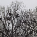
- Rookery
-
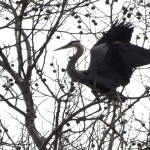
- Blue Heron
-
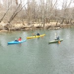
- Paddlers
Comments on this entry are closed.